
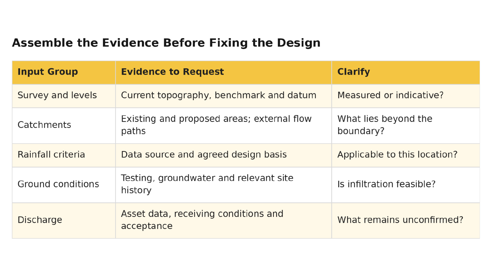
Stormwater design inputs should establish the site’s levels, contributing catchments, ground conditions and feasible discharge arrangements before the team fixes the grading design. Begin with a reliable survey and a record of the criteria the civil designer will use. Identify missing evidence, assign responsibility for obtaining it and explain which decisions remain provisional.
For Saudi commercial developments, review the building and its surroundings together. Entrances, parking, basement ramps and adjoining roads share level relationships that need coordinated assessment. This guide helps owners and project managers assemble the information needed for that assessment. It does not prescribe drainage sizes or replace a project-specific hydrological and hydraulic design.
Request a current topographic survey covering the plot and the surrounding features needed for the drainage assessment. Agree its extent with the civil designer. A survey ending exactly at the boundary may omit a road low point, upstream channel or neighbouring level that affects the proposed development.
Identify the survey datum, benchmarks, coordinates, date and revision. The architectural finished floor levels, road tie-ins and drainage levels should use a consistent reference. Where different surveys or utility records are combined, ask the surveyor and designer to reconcile their references before comparing elevations.
Include existing buildings, walls, kerbs, channels, inlets and relevant utility features. Record where levels or underground assets remain unverified. Distinguish measured information from indicative records; an assumed pipe invert should remain labelled until suitable verification is available.
Agree the survey deliverable format as well as its coverage. The design team may need usable digital terrain information, feature codes and a drawing showing the control references. Keep the survey’s physical features aligned with the legally established plot information, and raise discrepancies for resolution before relying on the affected boundary or level.
Record the agreed site information in the wider engineering design brief so the disciplines work from consistent inputs.
Provide existing and proposed site layouts with the intended surface types. Roofs, paving, landscape areas and undeveloped ground need to be identified in the catchment assessment. Ask the designer to explain how the proposed development changes the areas contributing runoff and the routes connecting them.
Look beyond rainfall falling within the plot. Request an assessment of upstream land, roads, channels and any known flow paths reaching the site. Include available flood studies, drainage records and reliable information about previous flooding. A dry inspection on one day does not establish the behaviour of the site during a storm.
Identify where existing flows leave the land and what lies downstream. Record neighbouring properties, road interfaces and receiving drainage features. If the wider catchment is uncertain, agree what additional survey, records or specialist investigation is required instead of treating the boundary as a hydraulic barrier.
Ask the civil designer to identify the rainfall data source, geographical coverage and issue date, together with the adopted design events and assessment method. Rainfall intensity, duration and event probability are different inputs; annual rainfall alone does not describe a design storm.
Record the criteria to be confirmed with the relevant municipality, development authority, infrastructure owner or other responsible party. The applicable requirements depend on the project and its interfaces. Saudi highway drainage guidance can inform a relevant road interface, but it should not be presented as the universal specification for every commercial plot.
Keep a short design-basis record showing which criteria are confirmed and which await agreement. Do not copy a return period, rainfall intensity or runoff assumption from another Saudi development without checking its applicability.
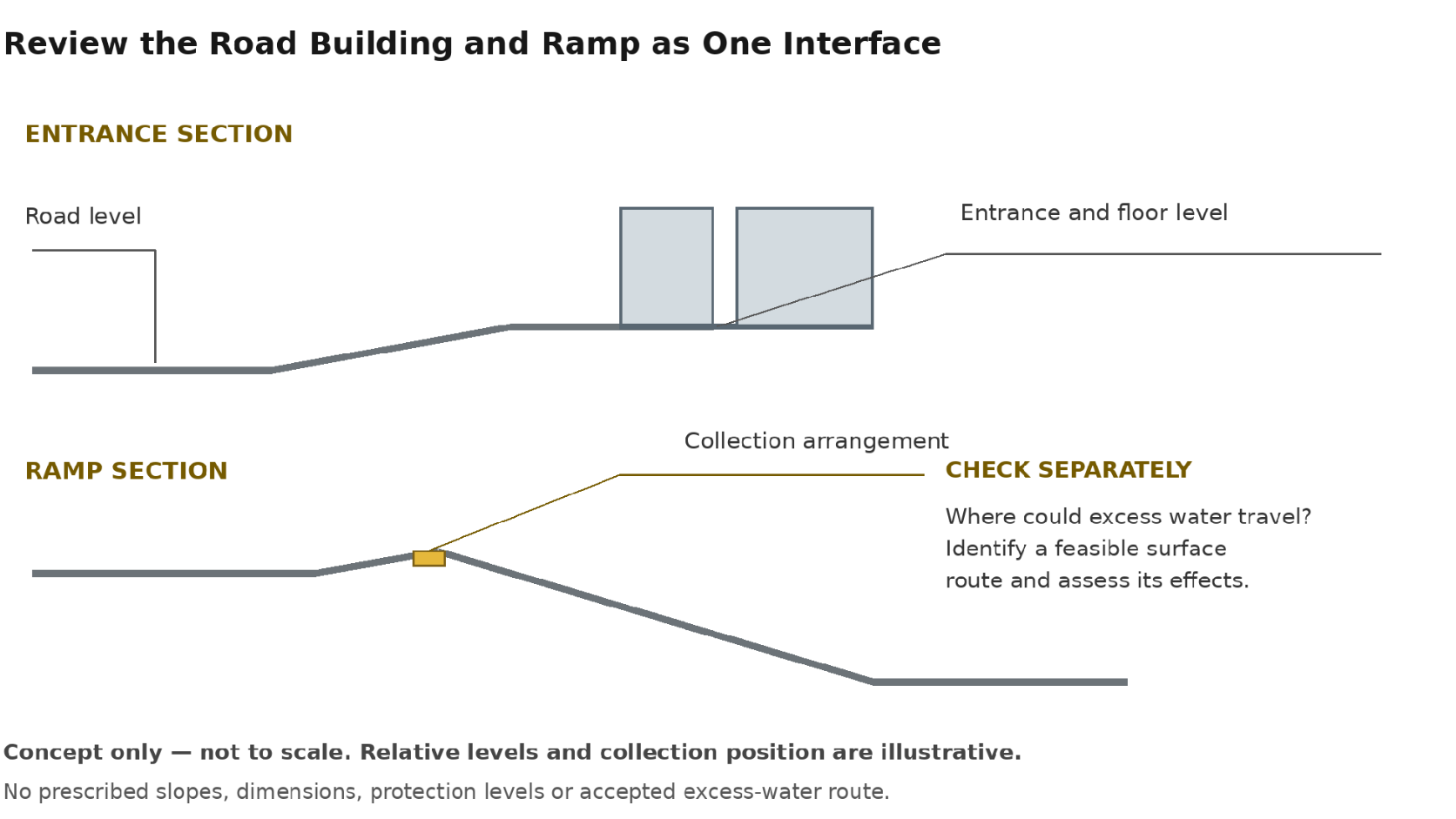
Provide proposed finished floor levels, entrance thresholds, basement ramp geometry, loading areas and external circulation layouts. Review these against the surveyed road and boundary levels. The architectural layout and civil grading plan should be developed together so changes in one are assessed in the other.
Ask for sections through critical interfaces, particularly entrances and ramps. A plan can identify a collection point, while a section makes the relationship between road level, ramp crest, building threshold and surrounding ground easier to review. Identify low points and areas where water could collect.
Include pedestrian accessibility, vehicle movements, landscape levels and retaining arrangements in the discussion. Raising one area can affect adjoining surfaces and routes. The team should evaluate those consequences rather than relying on a general instruction to slope everything away from the building.
Keep level decisions provisional where the external constraints remain unverified. Agree who can accept changes to the building brief and identify the drawings affected. This guide supplies no standard threshold allowance, ramp slope or finished floor elevation.
Identify the intended receiving system or other proposed discharge destination. Obtain available information about its location, levels, ownership and connection requirements. Ask what evidence supports its ability to receive the proposed flow under the assessed conditions.
An existing drain beside the plot does not establish permission to connect or prove available capacity. Separate the physical survey, hydraulic assessment and connection acceptance in the input register. Record any constraints on discharge and the status of discussions with the responsible infrastructure owner.
Ask the designer how receiving water levels and downstream restrictions affect the proposal. Where information is incomplete, document the assumption and its consequence for the design. Options involving storage, controlled discharge, infiltration or pumping need their own feasibility assessment; none is an automatic substitute for a confirmed outlet.
If infiltration is being considered, request site-specific ground information and appropriate testing. The assessment should address soil and subsurface conditions, infiltration behaviour, groundwater and relevant nearby constraints. A sandy-looking surface or a landscaped area is insufficient evidence of usable infiltration capacity.
Provide information about previous land use and potential contamination where relevant. US EPA guidance identifies groundwater conditions, soil characteristics and potential pollutants as considerations when assessing infiltration. These are general technical principles, not Saudi approval criteria or a prescribed local separation distance.
Ask the civil and geotechnical professionals to define the investigation needed for the proposed arrangement. Keep the infiltration option conditional until the evidence and applicable requirements support its use.
Ask where water could travel if the assessed drainage capacity is exceeded or an inlet becomes obstructed. Review surface routes alongside the underground system. Identify possible effects on building entrances, basement ramps, electrical assets, pedestrian areas and neighbouring land.
Provide proposed walls, kerbs, landscape features and access arrangements that could redirect or obstruct those routes. An apparently open route on an early concept may disappear when boundary treatments or later phases are added.
The designer should state the scenarios assessed and the limits of the information used. A drawn arrow alone does not establish acceptable flood depths, velocities or downstream effects. Any route requiring use of land outside the project also needs the relevant rights and acceptance to be resolved.
Share utility layouts, foundation and retaining proposals, landscape levels and irrigation information. Coordinate drainage corridors and structures with other underground assets, while retaining the access needed for inspection and maintenance. Identify any proposed changes to the roof drainage and site drainage interface.
For phased developments, explain which surfaces, outlets and access routes will exist at each stage. Temporary drainage during construction needs separate consideration where the permanent arrangement is incomplete. Ask the appointed team to define responsibilities for the temporary works and their maintenance.
Confirm who will operate and maintain the completed system. Include practical access requirements and handover information, and agree maintenance needs with the designer and operator for the actual assets.
Define the civil and building-system interfaces within the engineering design scope including the information each discipline must provide.
Consider an illustrative commercial development where the architectural concept includes a basement ramp beside the street. The initial plot survey omits the adjoining road low point. The civil review identifies that the external level and flow information is incomplete, so the proposed ramp arrangement remains provisional.
The survey scope is extended to capture the relevant road and boundary features. The civil designer assesses the external flows and reviews sections with the architect. The team then evaluates the ramp entrance, collection arrangements and other feasible measures using the confirmed information.
Record the selected approach, required technical checks and affected revisions. Do not close the issue simply because a trench drain appears on the plan. This is an instructional example; no ramp detail, drain size or protection level is established here.

Consider an illustrative retail site with a nearby public drain shown on an old utility record. The concept drainage layout assumes a connection, but the receiving level and connection acceptance are unconfirmed. Record both gaps and identify which calculations and layout decisions depend on them.
The project team seeks reliable asset information and clarification from the responsible owner. The designer checks the implications and assesses feasible alternatives if the assumed connection cannot be used. Any proposed storage or other arrangement must be evaluated against the project conditions and applicable requirements.
The input register should show the evidence required, responsible party, target date and consequence of delay. Keep the drainage arrangement provisional until the relevant decisions are resolved; an indicative connection line is not an accepted discharge agreement.
Before the next design issue, review the register with the owner, civil designer and affected disciplines. Each material input needs a source, revision, status and responsible party. Record how unresolved information limits the intended use of the design.
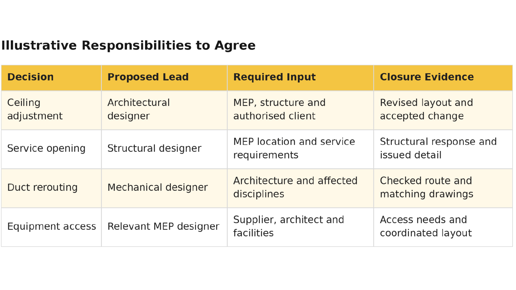
When a survey, building level, catchment boundary or discharge condition changes, identify the affected calculations and drawings for review. Retain the agreed evidence and outstanding decisions as the project’s stormwater design inputs.
Crown Axis provides civil design services, including grading, drainage and stormwater management. Share the site survey, proposed layout and available discharge information to discuss the required design inputs and coordination scope. Contact Crown Axis to clarify the information needed for your commercial development.
Early options can be explored using clearly identified provisional information where the appointed designer considers that useful. Record the assumed levels, missing survey coverage and decisions that cannot yet be fixed. Confirm the intended use of the concept so it is not mistaken for coordinated construction information. Replace assumptions with verified inputs before relying on the affected design decisions.
No. Its presence establishes neither available capacity nor permission to connect. Obtain suitable information about the asset, receiving conditions and owner requirements. Ask the civil designer to assess the proposed connection and record the acceptance status separately. If the data remains uncertain, explain which parts of the drainage design depend on that uncertainty.
Treat the landscape proposal as an input to assessment rather than an assumed disposal solution. Its contribution depends on the design and site conditions, including soil, groundwater, available space and potential pollutants. Infiltration proposals need appropriate investigation and review. Coordinate landscape levels and overflow arrangements with the civil design before assigning them a drainage function.
Review affected inputs when the survey, building footprint, finished floor levels, surface types, access arrangements or discharge conditions change. New external works or a revised development phase can also affect the assessed routes. Ask the designer to identify the calculations and drawings requiring updates, and retain the revision history with the current input register.
Browse through some of our proudest builds and transformations
We prioritize attention to detail and use high-quality materials for lasting, exceptional results.
We prioritize attention to detail and use high-quality materials for lasting, exceptional results.